Hillshade
The map service supports an optional hillshade query parameter that composites a shaded-relief overlay on top of the basemap. The overlay is rendered server-side from a Terrarium-encoded raster-DEM tile source and blended with the basemap using a multiply operation, so highlights leave the basemap untouched and shadows darken it.
Basic Behavior
- Hillshade is off by default.
- When enabled, a short attribution line is appended to the basemap's attribution:
Hillshade: Mapzen / AWS Terrain Tiles. A user-suppliedattribution=text:...override still wins. - The default tile source is the public AWS Open Data Terrain Tiles endpoint. The source URL can be overridden per deployment via the
HILLSHADE_TILE_URLenvironment variable (see Configuration).
Parameter Format
hillshade accepts a boolean-like value (true, 1):
&hillshade=true
Tile Source Requirements
The configured HILLSHADE_TILE_URL must serve Terrarium-encoded raster-DEM tiles (Mapzen/Tilezen format: elevation = (R*256 + G + B/256) - 32768 meters). Mapbox terrain-RGB tiles use a different formula and are not supported.
Public sources that serve Terrarium tiles:
- AWS Open Data:
https://s3.amazonaws.com/elevation-tiles-prod/terrarium/{z}/{x}/{y}.png(default) - Self-hosted via tilezen/joerd or a proxy of the AWS endpoint
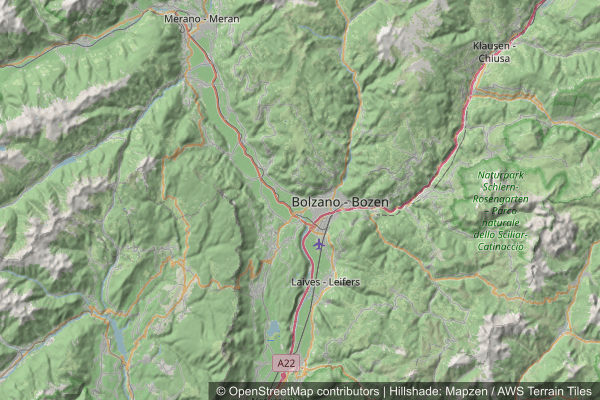
Hillshade example request
Attribution
When hillshade=true, the rendered attribution combines the basemap credit and the hillshade credit:
© OpenStreetMap contributors | Hillshade: Mapzen / AWS Terrain Tiles
The Mapzen Terrain Tiles dataset aggregates elevation data from multiple sources (NASA SRTM, USGS NED, GMTED2010, ETOPO1, GEBCO, ASTER GDEM and others). The full source list is documented in the joerd attribution doc.